How to Find Waves Around Quepos and Manuel Antonio
 So you are a surfer who is visiting Manuel Antonio with your family or friends. They don’t surf but they don’t mind if you wake up early and go for a session before breakfast. How do you know where to go?
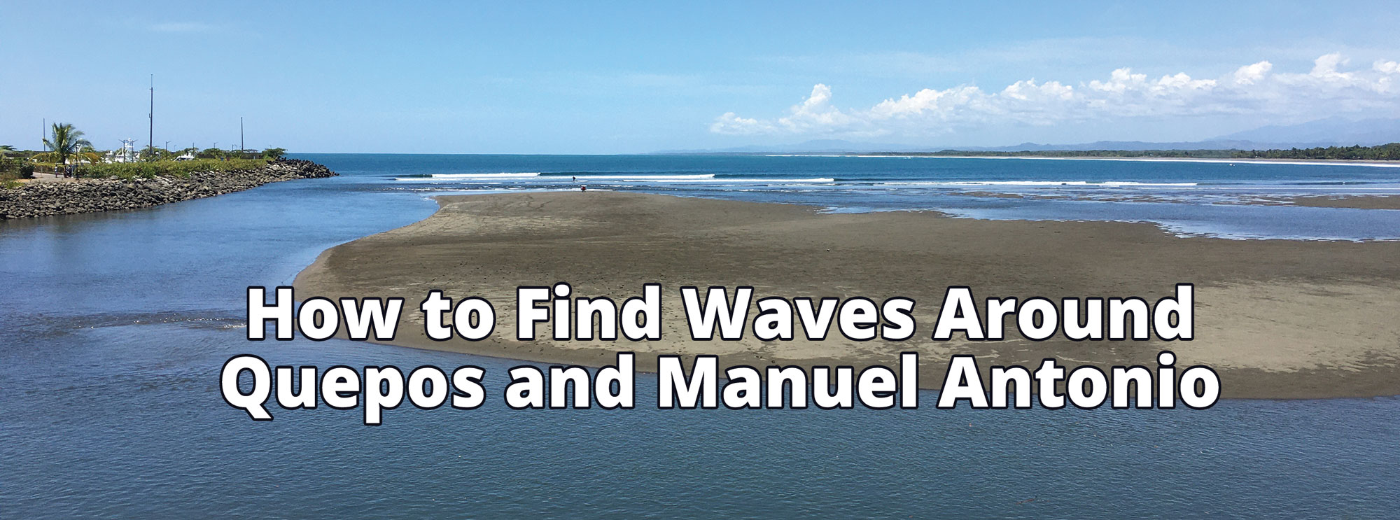
The first thing to check is the tide. Manuel Antonio is a high tide break. At low tide is mostly closes out. The only spot that does work well at low tide is the Quepos river mouth. To get there, you drive to Quepos and head towards the Pez Vela Marina. Right before the marina there is free parking and you can see the break straight out front. Be sure not to leave anything in your vehicle as break ins are common.
The Quepos rivermouth needs some swell in order to work and is mostly a longboard wave unless it gets to be chest high or bigger. When there is a massive swell, it still is not that scary and is a left breaking wave that you can ride for 300+ yards. There are a few locals who dominate the peak, but there is a second peak farther to the north and on the inside that is easy to sit on. And you could surf the break at mid tide or high tide, but after catching a long ride it is harder to get back to the peak. At low tide you can belly it to the sand bar and then walk up to the top of the break and use the river mouth rip to take you right back to the peak.
If it is high tide in the morning, then first you should drive down towards the national park. Tell the guys who ask to pay for parking that you are just checking it so they don’t charge you. In general if there is no swell then it will be knee high or less. You can surf just to the north of the park or anywhere along that stretch of coastline. The waves are about the same. Again, do not leave anything in your vehicle. This stretch is never crowded so you can find your own peak.
If you want bigger surf then you are going to want to check Playitas. You could get there by walking 15 minutes north from the parking near the park. You will pass a large 40 foot rock outcropping just off the beach and then you will see a smaller 8 foot tall rock about 40 yards off the beach. That is the southern end of the break and it goes about 100 yards to the north. Or you could drive right to it.
To get there by car from the national park, drive back north up the hill until you see the Jolly Roger Restaurant on the right and then turn left at the road for Los Altos Resort. If you pass the Barba Roja Restaurant on the left you went too far. Take that road downhill all the way to the beach. You can actually park on the sand (although it is illegal and not recommended). This road is very steep and if it is rainy you may need 4wd to get back up. Once again, leave nothing in the vehicle. Also be careful if driving on the beach as you can easily get stuck in the deeper sand.
Playitas has bigger waves and will also be more crowded with local surfers. Some of them are very protective of their break and so be sure to be respectful when sharing a peak, or just paddle down a little to the next one. In my experience the best spots are at the far north and south ends of the break. There are some rocks on the inside that could be dangerous when paddling back out or at the end of your ride. It is best to first sit and watch the sets and the surfers out to see what the currents are doing and what spot is the least crowded.
So you can enjoy some early morning sessions while your non-surfing friends or family sleeps in. The winds are generally best early and the peaks the emptiest. Just be sure to check the tides first so you save time knowing where to check it first. You can find the tide charts on our website for the whole year, crsurf.com/costa-rica-surf-report/costa-rica-tide-charts-2022