Where the River Meets the Sea
By Jim Parisi
Costa Rica is blessed with a sturdy backbone, the Cordillera Central Mountain Range that runs north and south through the center of the country. Being close to the equator, Costa Rica receives a lot of rainfall. This “backbone” helps distribute this vast amount of fresh water to the east, where it eventually empties into either the Caribbean Ocean, or to the west and the shores of the Pacific Ocean. The result is a veritable spider web of waterways that meander throughout this country before ultimately converging with the salty oceanic waters, where the rivers meet the sea.
Webster’s dictionary defines estuary quite simply as “an arm of the sea that ebbs at the lower end of a river”. The unique estuaries at the mouth of many Costa Rica rivers have been relegated as refuge areas included in the National Parklands. The Sixaola River creates part of the border between Costa Rica and Panama, originating in the Cordillera and emptying into the Caribbean Ocean. The river is also the southern boundary of the Gandoca Manzanillo Wildlife Refuge, twenty-three thousand acres classified as “humid tropical rainforest” that accommodates a ten kilometer strip of Caribbean beachfront. The refuge houses the only known orey and jolillo pond swamps in Costa Rica as well as the only natural oyster beds in the Caribbean reefs that extend all the way to Cahuita. This small village is the historic birthplace of Walter Ferguson, Father of Calypso, who still performs there on occasion. The park is a natural habitat for the harpy eagle, mot-mots, and toucans; the marine life in the crystal-clear reefs includes anemones, blue parrot fish, sea cucumber, and angel fish, a dream come true for snorkelers.
This area has also caught on for the Salsa Brava surf break south of Puerto Viejo and Playa Cocles, just outside Cahuita. Gaining in stature, it is a “secret spot” no more, as businesses crop up to accommodate the surfing culture. The area receives rain year-round but two of its drier months are September and October, a good time to visit, since historically the rest of the country receives the most precipitation in those two months.
On the north end of Costa Rica’s Caribbean shoreline is Barra de Colorado Wildlife Refuge, established in 1982. It embraces a massive 225,000 acres, bordering Nicaragua with the San Juan River. This verdant primary forest, unscathed, is inaccessible by road. There are no buses or public transportation that go there and it can be reached only by private riverboat, seafaring ships, or by the tiny gravel airstrip next to the Colorado River; a real-life Indiana Jones experience. One main draw to the region is the fishing, which includes trophy tarpon, snook, and rainbow bass in the freshwater rivers, and barracuda, mackerel, and jack creville offshore. The area receives an incredible 234 inches of rainfall a year, part of the reason that kayakers, photographers, and canoers also make this a destination point. Along with Rio Colorado and Rio San Juan, the raging Rio Chirripo make this a prime locale for long-billed birds, such as the glossy ibis, wood stork, snail kite, green-backed heron and black-necked stilt. In a country full of natural wonders, Barra de Colorado is truly an isolated, pristine paradise.
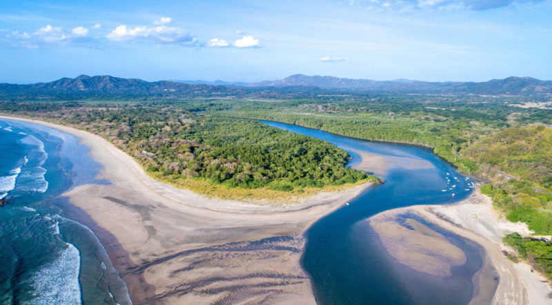
Weather patterns dictate water distribution, so historically, the Caribbean side of Costa Rica has received more rainfall than the Pacific side. But that doesn’t mean the western half of the country is arid. The southwestern tip of the Nicoya Peninsula has been a “discovered” secret surf spot, especially in the Santa Teresa—Malpais stretch of beach. But just north of there lies the Rio Bongo Estuary, part of the immense Caletas Ario Wildlife Refuge, consisting of 775 acres of natural preserve, including seven kilometers of pristine beachfront. This impressive parcel of land was donated in 2008 by the Grew family from Canada.
The Rio Bongo forms the border between Guanacaste and Puntarenas Provinces. It is the largest river on the Nicoya Peninsula, joined by Rio Ario and Rio Cano Seco very near the river mouth in the estuary. The beaches support four species of turtles making it one of the most important nesting sites in Costa Rica. Here, one can find Leatherback and the common Olive Ridley and Pacific Green as well as the rare Hawksbill turtles. Poaching of shells and eggs has long been a problem but recently CIRENAS (Centro de Investigacion de Recursos Naturales) has stepped in to curtail this activity. This independent organization is set within the refuge and focuses on research and education of water conservation and management, sustainable food production and ecologically viable housing. Playa Manzanillo is one of the largest communities in this area. If you are visiting in the month of March, be sure to participate in the Sandcastle Party.
Further south down the Costa Rica coastline is the town of Pavones, with a series of small beaches interspersed with rocky coastline. But the surf is good here, as it is a Playa Zancudo and Punto Banco, each a few miles to the north and south, respectively. Pavones is home to several waterfalls within view of the beach, including Tiskita, which boasts a drop of more than one hundred feet. The Rio Claro empties in the ocean here, at Golfo Dulce, creating a biological wonderland, Piedras Blancas National Park. This park was formerly a part of the legendary Corcovado National Park. It is the home of the self-sufficient indigenous Guaymi people who often bring their handmade crafts into Pavones to sell. The area receives more than two hundred inches of rain a year, so be sure to bring your umbrella.
The estuaries in this small country are plentiful and most are being watched now with a mindful eye. So many species of flora and fauna exist primarily, if not only, here. It simply makes sense, for the sake of future generations and for your personal pride, to remember to be respectful when visiting any of them.
For the sake of future generations and for the planet itself, be respectful when visiting these majestic waterways.